Monday, 15 October 2012

Vasstinden

We just had a beautiful autumn weekend here in northern Norway and, as we need to enjoy every bit of sunshine we can get these days before the polar night starts, we were out hiking both days. Saturday was not as sunny as it was supposed to be, but instead we got some beautiful clouds and light.

We hebben net een prachtig herfst weekend gehad hier in het noorden van Noorwegen en we zijn dan ook op beide dagen gaan de bergen in gegaan. De poolnacht komt er alweer snel aan en we willen dus al het zonlicht dat we kunnen krijgen benutten. Zaterdag was niet zo zonnig als voorspelt, maar de wolken en het licht waren prachtig.


Sun rays over Kvaløya


Beautiful clouds over Vengsøya

On Sunday, however, we had blue skies, no wind, and fresh snow on the tops of the mountains. A perfect day for a decent hike. We chose Vasstinden, ca 40 km west of Tromsø, one of the mountain walks on Kvaløya that we hadn't done yet and, more importantly, a walk that would be in the sun all day. A steep start, followed by a more gentle top ridge with stunning views in all directions. Out over the Atlantic Ocean to the west, Senja to the south and the snowy mountains of the mainland and Lyngen to the east. The snowline lies at around 700 m elevation at the moment so much of the final ridge was covered by snow and we got to throw the first snow balls of the season.

Zondag was het prachtig weer met een blauwe hemel, geen wind en verse sneeuw op de bergtoppen. Een prachtige dag voor een wandeling. We kozen Vasstinden, ca 40 km ten westen van Tromsø, een van de bergwandelingen op het eiland Kvaløya die we nog niet gemaakt hadden en, belangrijker, een die de hele dag in de zon zou zijn. Een steile klim in het begin, maar daarna kom je op een vlakkere rug met prachtig uitzicht naar alle kanten, de Atlantische oceaan in het westen, het eiland Senja in het zuiden en de besneeuwde bergtoppen op het vasteland en in Lyngen in het oosten. De sneeuwgrens ligt op dit moment op ongeveer 700 m hoogte en het laatste stuk langs de rug was in de sneeuw. En we hebben dus de eerste sneeuwballen van het seizoen gegooid.


Out of the forest and heading up to the ridge

View to the south

The rugged granite peaks of the Ersfjord granite on Kvaløya to the east

The gentle ridge to the top

Tony throwing his first snowball of the season

View from the top to the southwest, with the bridge to Sommarøya, and the island Senja in the background

Obligatory top photo, but the low hanging clouds block the view to the west

Down along the snowy ridge

Ptarmigan tracks

Evening light over Kvaløya

Saturday, 6 October 2012

Trondheim - Frøya

I had a couple of hours in Trondheim before I had to catch the hurtigbåt to Frøya where the oil spill clean-up exercise would be held. So I spent 2 hours walking around town to see some of the main attractions, the Nidaros cathedral and Archbishop's palace, the old town bridge and river front warehouses, and the Kristiansten fortress with it's excellent view over the city.

Ik had een paar uur in Trondheim voordat de boot naar Frøya vertrok, waar de olievervuiling opruim oefening gehouden zou worden. Dus ik had tijd om door Trondheim te wandelen en een aantal van de bekendste bezienswaardigheden te bezoeken, de Nidaros katedraal en het paleis van de aartsbisschop, de oude stadsbrug en warenhuizen, en het Kristiansten fort met prachtig uitzicht over de stad.

Aerial photo of the islands Kvaløya, Håja and Vengsøya, just west of Tromsø

Somewhere north of Bodø

The impressive Nidaros cathedral in Trondheim

A detail from the Nidaros cathedral

Detail from the Archbishop's palace

Colourful warehouses along the river Nidelven

A prison cell in Kristiansten fortress

Nice autumn colours here too

Most of the time on Frøya was of course taken up by the exercise, but there were a few hours of daylight left after the exercise to explore part of Frøya together with another WWF volunteer. The island is quite flat and open, the highest point is just under 100 m, with many lakes full of fish: we came across a school class who had been out fishing and they showed us 2 buckets full with fish.

Na de olievervuiling oefening hadden we nog een paar uur met daglicht om Frøya te bekijken en samen met een andere vrijwilliger van WWF heb ik een mooie wandeling gemaakt in het 'binnenland' van Frøya. Het eiland is vrij vlak en open, het hoogste punt is net onder 100 m meter hoog, met visrijke meren. We kwamen een schoolklas tegen die ons 2 emmers vol met vis lieten zien.

Lakes, swamps and rocky outcrops

And huts of course, we are in Norway.

Oil spill clean-up exercise 'Njord' on Frøya

As a WWF volunteer in their clean coast program (see also my post on Røst), I joined a big oil spill clean-up exercise on Frøya, an island west of Trondheim. This was a very well organised exercise that gave everyone useful practical experience in using different types of equipment, team work and communication, and discussing different approaches for containing a spill and cleaning up. I participated in one of the coastal clean-up teams, but there were also several boat teams that tried to contain and clean up an oil spill at sea to prevent it reaching the coast. And for those who wonder: popcorn is used to represent oil in these exercises.

Ik ben een vrijwilliger voor WWF's 'schone kust' programma (meer informatie hierover in een eerdere blog over Røst) en zij hadden 10 vrijwilligers nodig om mee te doen aan een grootschalige olievervuiling oefening op Frøya, een eiland ten westen van Trondheim. Het was een goed georganiseerde oefening en iedereen deed erfaring op met de verschillende werktuigen, team werk en communicatie, en het bespreken en uitproberen van verschillende methodes om de vervuiling te beperken en op te ruimen. Apart van de teams op land waren er ook verschillende boot teams die vervuiling op zee probeerden op te ruimen om te verhinderen dat het de kust bereikte. De olievervuiling wordt in deze oefeningen gesimuleerd met popcorn.

The 'criminal' caught in action spilling 2000 liters of 'oil' (popcorn)

Here we have contained the spill with an oil boom to prevent further spreading

One of the other teams is cleaning up a beach

Here is our base with equipment storage and with Sivilforsvaret's orange tent where they look after us with food, drinks and first aid

Nearly finished: my team collecting the last popcorn

Monday, 1 October 2012

Simavikdalen - Simavikrygget on Ringvassøya

A nice walk on a beautiful autumn day. Up along the gravel road to the dam at Øvre Langvatnet in Simavikdalen, then the track around the lake and cross country up Simavikrygget. Beautiful autumn colours, thin ice in one of the small lakes, fresh snow on the tops and impressive skies.

Een prachtige wandeling in heerlijk herfstweer. Eerst langs een gravelweg door het Simavikdal omhoog naar het stuwmeer Øvre Langvatnet, dan een wandelpad langs het meer en uiteindelijk recht omhoog naar de top. Prachtige herfstkleuren, een dunne ijslaag op een meertje, verse sneeuw op de hogere toppen en indrukwekkende wolken.

Good gravel road up to the dam - a family out on a Sunday walk

Autumn colours

Last part of the road up to the dam

Friendly locals

The dam - supplying Tromsø with drinking water

Thin layer of ice with large ice crystals

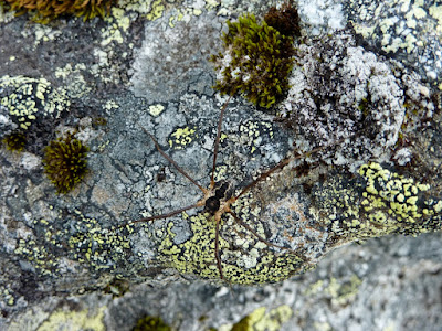
Lots of (harmless) spiders walking around

Beautiful cloud formations and light

Fresh snow on Tromsdalstinden

... and on some of the higher local mountains

View from the top back to the dam and Simavikdalen

Tony walking on a green mountain 'road' (an eroded sheared dyke)