Wednesday, 6 May 2009

Fairbanks #3, around Fairbanks

Spring has come! After 2 weeks with warm weather with several days over 20˚C most of the snow around Fairbanks has now melted and the birch trees are starting to sprout their leaves. Very little in terms of spring flowers though, nothing like Tromsø. The warm weather is also causing the rivers to break up, with some severe flooding along the Yukon river. The village Eagle some 200 km southeast of Fairbanks is being swiped away by enormous ice blocks in the worst flooding in recorded history (see photos on: http://newsminer.com/photos/galleries/2009/may/05/2009-breakup-flooding/2030/). Also the Chena river, which flows through the centre of Fairbanks, showed a spectacular breakup flooding on Saturday. We missed it, unfortunately, as we were hiking up in the hills, but saw a photo in the local newspaper (http://newsminer.com/photos/galleries/2009/may/05/2009-breakup-flooding/2019/).

Below is a selection of photos from around Fairbanks, moose walking around the house, skiing in the Delta Range 150 km south of Fairbanks, Denali national park and some photos of the local hills.


Moose around the house

Moose around the house (taken from bedroom window)

Breakup in Denali national park

Railway bridge, Alaska range

Dall sheep

Camping on the Castner glacier

Skiing down from Triangle Peak towards Castner glacier

'Girl's' trip to Castner glacier and Thayer hut

Thayer hut

White mountains, north of Fairbanks

Near Chena Hot Springs, west of Fairbanks

Tanana river, just south of Fairbanks

Hiking up Murphy Dome in 23˚C on May 2nd

Sunday, 12 April 2009

Fairbanks #2, Nome and the Iditarod

In the middle of March we went to Nome for a couple of days to see the first Iditarod dog teams come in. Nome, in western Alaska, is the finish for the 1049 mile (ca 1700 km) Iditarod dogsled race from Anchorage; it is also the commercial centre for northwest Alaska. Nome started as a gold mining town, it became famous in 1899 when gold was found on the beach and in 1900 it was the largest city in Alaska with about 20000 inhabitants. This number has now dropped to about 2000 inhabitants, but there is still gold mining in the area and it is still possible to pan for gold on the beach. Nome is on the coast and therefore windier than Fairbanks, so it felt a lot colder. The first 1.5 days, waiting for the Iditarod winner to arrive, we explored Nome, visited the museum, went to a performance of the local King Island dancers, walked on the sea ice and 'explored' the Nome 'national forest' (they plant old Christmas trees and large animal statues on the sea ice). And, of course, we kept checking the status of the Iditarod teams, many of which had decided to shelter from the major storm battering the coast and the Yukon river in these days. Wednesday morning, however, the town's firealarm went off, indicating a dog team approaching Nome, and we raced down to the finish chute to see Lance Mackey arriving with 15 dogs to become the Iditarod winner for the third year in a row. From now on, every time a new dog team approached Nome, the firealarm would go off and tourists and locals would come out of the hotels, pubs and workplaces to cheer the incoming team to the finish. A great atmosphere, although the TV teams and reporters were a nuisance, crowding around the dogs and sled blocking the view for others. On Thursday morning we volunteered to work the early morning shift in the dog lot, taking care of dropped dogs and helping the vets to check the incoming dog teams. A great trip!
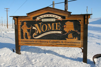
Welcome to Nome

A familiar face: Roald Amundsen. He landed near Nome with his airship Norge after the first transpolar flight in 1926.
Een bekend gezicht: Roald Amundsen, de beroemde Noorse poolreiziger landde in 1926 in de buurt van Nome met de zeppelin Norge na de eerste succesvolle vlucht over de noordpool.

A performance by the Kong Island dancers and musicians.
Een voorstelling van de King Island dansers en muzikanten.

The Nome 'national forest'
Het 'nationale bos' van Nome

Iditarod 2009 winner Lance Mackey arriving at the finish
Aankomst van Iditarod 2009 winnaar Lance Mackey 

Lance Mackey's two leaddogs get some well deserved attention
Lance Mackey's twee leiders krijgen wel verdiende aandacht

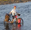
Different means of transport for different seasons
Transport type hangt af van het seizoen

Sebastian Schnuelle, with his father, on their way to park his dog team after finishing number 2
Sebastian Schnuelle, en zijn vader, op weg naar de hondenrustplaats nadat hij als tweede is binnengekomen

Gold dredge
Goudbaggermachine

Running up the bank from the sea ice...
Vanaf het zeeijs omhoog rennen...

... onto the main street in Nome to the finish line
...naar de hoofdstraat van Nome op weg naar de finish

View of the hills in western Alaska from the plane
Uitzicht over de heuvels in west Alaska vanuit het vliegtuig

View of the mighty Yukon river
Uitzicht over de Yukon rivier

View of Denali
Uitzicht naar Denali

Sunday, 15 March 2009

Fairbanks #1, dogs and ice

I have now been in Fairbanks for nearly 2 months, quite a change from Norway! I am working with the people from the geochronology lab here at the university and it is great being able to discuss geochronology again and getting back into this field. Outside work we have been taking a ski mountaineering course, which finished last weekend with a weekend trip up the Castner glacier to practice glacier travel and rescue techniques. Hopefully we will now be able to join some of the Alpine Club weekend trips to get more experience. The last few weeks we have had ice carving competitions in Fairbanks, first the single block competition where teams of 2 people get 2.5 days to make an ice sculpture out of a single large block of ice. Then the multiblock competition where teams of 4 have 6 days to create a sculpture(s) out of 5 large blocks of ice. The results are absolutely amazing, particularly the work by the Japanese teams. I will include a few photos of some of the sculptures below. Another popular activity in Alaska is dogsledding, and very much so here in Fairbanks. In February we watched the first 3 dog teams come in from the Yukon Quest, a ca 1600 km dogsled race from Canada along the Yukon river to Fairbanks. Today, we watched the North American championships, 4, 6, and 8-dog sprint races. These dogs are amazing! On Monday we fly to Nome on the southwest coast of Alaska for a few days. The famous Iditarod sleddog race, some 1800 km from Anchorage (Willow) to Nome, is on its way and we are hoping to see the first teams cross the finish line in Nome.

Iditarod sleddog race: http://www.iditarod.com
Nome webcam: http://www.nomealaska.org/vc/cam-page.htm
Fairbanks webcam: http://newsminer.com/arcticcam/

And some photos:

The winner of the Yukon Quest, Sebastian Schnuelle.

Number 3 in the Yukon Quest, Jon Little.

View from the university towards the Alaska Range in the south.

Dutch team in the single block ice carving competition.

The Japanese single block sculpture, the kingfisher.

Single block: the muskoxen.

Multiblock competition: Turtle.

Japanese entry in the multiblock, a pack of wolves chasing a caribou. The photo shows only half of the sculpture.

Multiblock entry.

8-dog sprint races in the North American Championships.

Wednesday, 7 January 2009

Kharkhorin - Ulaanbaatar 20-27 August 2008

After our first proper coffee in many weeks, in a French run café in Kharkhorin, we started cycling out of Kharkhorin when we were stopped by a young woman on a bicycle who asked if we knew anything about computers. Tony does, so we followed her to her house to see if there was anything Tony could do. Unfortunately there wasn't as the system needed to be reinstalled and they could not find the system disks, but it was interesting meeting this young Mongolian student. We left late, but the road was good, asphalt!, and although we had head wind, we cycled the 80 km to the Mongol Els sand dunes in the afternoon. Maybe we did get fit after all, you just don't notice it struggling up hills on rough tracks ;-). The Mongol Els are a tourist attraction and this means that there are lots of gercamps around, so we stayed in a luxury ger camp with showers and good food. After strolling around the sand dunes for half a day we had another 2 days of smooth riding on good asphalt roads until we crossed the Tuul Gol at the village Lün. There used to be an asphalt road all the way between Ulaanbaatar and Kharkhorin, which is one of the busiest roads in mongolia. But now, from just outside Lün, 150 km west of Ulaanbaatar, til ca 10 km outside Ulaanbaatar, the old road was broken up and no alternative road was provided. So now we were back to Mongolian style 'roads', drive whereever you want, and we could choose between about a dozen different tracks across the whole width of the valley. Apparently, this had been like this for 2 years; imagine them doing this in Europe! We stopped for half a day in Hustai national park, 100 km west of Ulaanbaatar, where we spotted several different types of falcons and, of course, the famous Przewalski horses. The last day cycling back to Ulaanbaatar was windy, wet and cold; the last 10-20 km cycling into and through Ulaanbaatar in crazy traffic is not something I would recommend, but we didn't have much choice. Back in Ulaanbaatar, we still had two days before our flight back, to clean everything, to enjoy the good food and try to fatten up a bit again.

Our route in this blog (green line)
Onze route in deze blog (groene lijn)

Mongol Els sand dunes
Mongol Els zandduinen

Insect tracks in the sand
Insektensporen in het zand

Lizard
Hagedis

Main road from Kharkhorin to Ulaanbaatar
Hoofdweg van Kharkhorin naar Ulaanbaatar

One of the many herds of sheep and goats
Een van de vele schapen en geiten kuddes

Pedestrian crossing? Where to?
Voetgangersoversteek? Waarheen?

Our campsite along the Tuul Gol near Lün
Campingplek langs de Tuul Gol bij Lün

The last 150 km to Ulaanbaatar - 'roadworks'
De laatste 150 km naar Ulaanbaatar - opgebroken weg

Cricket
Krekel

Sunday, 16 November 2008

Bayankhongor-Kharkorin 12-19 August

From Bayankhongor we headed back into the mountains to the northwest towards Kharkhorin. The first stop was Shargaljuut, an area with hot springs and an old fashioned sanitorium. After that we tried to get to the Orkhon valley via Naiman Nuur national park although we were uncertain if there were any tracks going all the way through. After several passes and a lot of asking directions at gers we got to the southern most lake in the volcanic Naiman Nuur area and there the road stopped. However, we could see the other end of the lake with the binoculars and it looked like there were some people camping with a truck. We decided to follow the horse trail around the lake to try to pick up the track on the other side. The horse trail started easy but got very rocky and steep near the end of the lake. Fortunately for us, the Mongolian family camping on the other side of the lake saw us struggling and 2 young guys came to help us carry the bikes and luggage over the last 200 m of the steep horse trail. Two days of cycling along the edge of a lava flow brought us to the Orkhon valley and the Orkhon waterfall. It was a bit of a culture shock to arrive at the waterfall, ger camps all around and 100-200 mostly Mongolian tourists. We have now clearly arrived on the popular tourist routes and the next day, after 6 weeks of cycling through Mongolia, we saw the first other tourist cyclists near Khujirt. Between Khujirt and Kharkhorin the asphalt started and we expected to have an asphalt road all the way back to Ulaanbaatar, ca 400 km. In Kharkhorin we stayed in a ger camp just outside the famous Erdene Zuu monastery. And to everyone's surprise, we met Freek and Ellen in the ger camp in Kharkhorin! I knew of course that they were in Mongolia, but not when they would be in Kharkhorin. We had 2 hours overlap and exchanged travel experiences over a nice lunch.


Our route in this blog (green line)
Onze route voor deze blog (groene lijn)

Shargaljuut hot springs
Shargaljuut hete bronnen

Shargaljuut sanitorium

The landscape has changed to grassy hills
Het landschap is veranderd in gras bedekte heuvels

First view of the main lake in the Naiman Nuur volcanics lakes national park
Eerste zicht op het grootste meer in het Naiman Nuur nationale park

Following a horse trail along the lake
We volgen een paardenpad langs het meer

Larch forest in the Naiman Nuur area
Larixbos in het Naiman Nuur gebied

A lavaflow has filled the valley, the track follows the edges
Een lavastroom heeft het dal ingevuld, het pad volgt de grillige rand

Tourist attraction: the Orkhon Khurkhee waterfall
Touristenattractie: de Orkhon Khurkhee waterval

The Orkhon Gol valley

Outer wall of the Erdene Zuu monastery in Kharkhorin
Buitenmuur van het Erdene Zuu klooster in Kharkhorin

Temples in the Erdene Zuu monastery

Inside one of the tempels of Erdene Zuu
Binnenin één van de tempels van Erdene Zuu