Sunday 16 November 2008

Bayankhongor-Kharkorin 12-19 August

From Bayankhongor we headed back into the mountains to the northwest towards Kharkhorin. The first stop was Shargaljuut, an area with hot springs and an old fashioned sanitorium. After that we tried to get to the Orkhon valley via Naiman Nuur national park although we were uncertain if there were any tracks going all the way through. After several passes and a lot of asking directions at gers we got to the southern most lake in the volcanic Naiman Nuur area and there the road stopped. However, we could see the other end of the lake with the binoculars and it looked like there were some people camping with a truck. We decided to follow the horse trail around the lake to try to pick up the track on the other side. The horse trail started easy but got very rocky and steep near the end of the lake. Fortunately for us, the Mongolian family camping on the other side of the lake saw us struggling and 2 young guys came to help us carry the bikes and luggage over the last 200 m of the steep horse trail. Two days of cycling along the edge of a lava flow brought us to the Orkhon valley and the Orkhon waterfall. It was a bit of a culture shock to arrive at the waterfall, ger camps all around and 100-200 mostly Mongolian tourists. We have now clearly arrived on the popular tourist routes and the next day, after 6 weeks of cycling through Mongolia, we saw the first other tourist cyclists near Khujirt. Between Khujirt and Kharkhorin the asphalt started and we expected to have an asphalt road all the way back to Ulaanbaatar, ca 400 km. In Kharkhorin we stayed in a ger camp just outside the famous Erdene Zuu monastery. And to everyone's surprise, we met Freek and Ellen in the ger camp in Kharkhorin! I knew of course that they were in Mongolia, but not when they would be in Kharkhorin. We had 2 hours overlap and exchanged travel experiences over a nice lunch.


Our route in this blog (green line)
Onze route voor deze blog (groene lijn)

Shargaljuut hot springs
Shargaljuut hete bronnen

Shargaljuut sanitorium

The landscape has changed to grassy hills
Het landschap is veranderd in gras bedekte heuvels

First view of the main lake in the Naiman Nuur volcanics lakes national park
Eerste zicht op het grootste meer in het Naiman Nuur nationale park

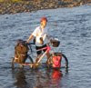
Following a horse trail along the lake
We volgen een paardenpad langs het meer

Larch forest in the Naiman Nuur area
Larixbos in het Naiman Nuur gebied

A lavaflow has filled the valley, the track follows the edges
Een lavastroom heeft het dal ingevuld, het pad volgt de grillige rand

Tourist attraction: the Orkhon Khurkhee waterfall
Touristenattractie: de Orkhon Khurkhee waterval

The Orkhon Gol valley

Outer wall of the Erdene Zuu monastery in Kharkhorin
Buitenmuur van het Erdene Zuu klooster in Kharkhorin

Temples in the Erdene Zuu monastery

Inside one of the tempels of Erdene Zuu
Binnenin één van de tempels van Erdene Zuu

Tuesday 12 August 2008

Altai-Bayankhongor 9-11 August

Just a short note.... We did manage to arrange transport from Altai to Bayankhongor, and got our experience of travelling Mongolian style. 15 people and a lot of luggage, including our bicycles, in a small minivan, it took 22 hours to cover 400 km. This says a lot about the condition of this main road (horribly corrugated and sandy), but also about the condition of the vehicle and Mongolian driving. We got stuck in a river in the middle of the night and it took about an hour to get the van out and another couple of hours to get the engine going again. After that the engine kept overheating. One of the 2 drivers got stuck in the vodka after he had driven the first 1.5 hours and the other driver had to to do all the remaining driving and engine fixing. But we arrived and are now about to head back into the mountains on our bicycles.

Een kort bericht... Het is ons gelukt om transport te regelen van Altai to Bayankhongor en we hebben nu dan ook de Mongoolse manier van reizen ervaren. 15 mensen en een heleboel bagage, inclusief onze fietsen, in een klein personenbusje, waarschijnlijk bedoeld voor 8 man. Het duurde 22 uur om 400 km af te leggen, en dit zegt veel over de conditie van de weg (vreselijk), maar ook over de conditie van de auto en de Mongoolse rijstijl. Midden in de nacht kwamen we vast te zitten in een rivier en het duurde een uur voordat we het busje weer op het droge hadden en nog een paar uur voordat de moter het weer deed. Daarna bleef de moter voordurend oververhit. Een van de 2 chauffeurs begon aan de vodka nadat hij 1,5 uur gereden had en de andere chauffeur moest daardoor verder al het rijden en het repareren alleen doen. Maar we zijn hier aangekomen en gaan nu weer op de fiets verder de bergen in.


Our route in this blog (dashed green line)
Onze route in deze blog (groene stippellijn)

Loading of the minibus in Altai
Het laden van de minibus

Somewhere between Altai and Bayankhongor: desolate, dry, sandy and corrugated
Ergens tussen Altai en Bayankhongor: verlaten, droog, zandig en een wasboordweg


Saturday 9 August 2008

Khovd-Gobi-Altai 22 July-8 August

A long stretch without internet... From Khovd we headed southeast, back into the mountains, to find a cave with rock paintings. Beautiful mountains with narrow valleys where the road stops and a horse/motorbike trail continues. No problems with water here; one day we had to cross the river more than 30 times. After the cave we headed south across the mountains to the start of the Gobi desert, near the Chinese border, to see the solar eclipse. The desert was dry and hot, but we had clear weather for the eclipse and found a good spot to watch this. We weren't the only ones to come to this spot for the eclipse; some 2 dozen tourgroups had also selected this spot and the little village nearby was swamped with foreigners. After the eclipse we cycled back across the mountains to the northeast and took 3 days to cross a little desert on our way to Altai, where we arrived yesterday. From here we will be going east towards Ulaanbaatar, but we will try to skip the less interesting part across the plains to Bayankhongor, 400 km to the east, and get a ride on a truck. A selection of photos follows below, enjoy!

Bijna 3 weken zonder internet.... Vanaf Khovd zjn we naar het zuidoosten gefietst, terug in de bergen, op zoek naar een grot met rotstekeningen. Prachtige bergenmet smalle dalen waar de weg ophoudt en een paarden/motorfietspad doorgaat. Geen problemen met water hier; een dag moesten we meer dan 30 keer de rivier oversteken.Na de grot zijn we over de bergen naar het zuiden gefietst naar het begin van de Gobi woestijn vlakbij de Chinese grens om de zonsverduistering te bekijken. De woestijn was droog en heet, maar we hadden mooi weer voor de zonsverduistering. We waren niet de enige die deze plek hadden uitgekozen; zo'n 20 tourgroupen waren ook hier naar toegekomen en het dorpje vlakbij werd dan ook overspoeld met touristen. Na de zonsverduistering zijn we terug over de bergen gefietst richting het noordoosten. Na de bergen heeft het ons 3 dagen gekost om een kleine woestijn door te steken op weg naar de provinciale hoofdstad Altai, waar we gisteren aangekomen zijn. Van hier gaan we naar het oosten, richting Ulaanbaatar, maar we willen proberen om de volgende 400 km naar Bayankhongor een lift te krijgen van een vrachtwagen. Dit stuk ziet er nogal saai uit op de kaart, vlak en daarom waarschijnlijk droog, heet en zandig. Hieronder een kleine selectie van foto's van de afgelopen 2,5 week, veel plezier!

Our route for this blog (green line)
Onze route voor deze blog (groene lijn)

One of the mountain valleys
Een van de mooie bergdalen


River crossing number 27...
Rivieroversteek nummer 27...


Forested valley
Dal met bos


We camped together we a French tourgroup and some local herders came to deliver marmots in the morning
We kampeerde samen met een Franse group en de lokale herders kwamen 's ochtends met marmotten aan


Rock paintings in cave
Rotstekeningen in een grot


The start of the Gobi desert
Het begin van de Gobi woestijn


We are not the only tourists here...
We zijn hier niet de enige touristen...


Sun coming back
Terugkeer van de zon


Checking how far the moon had got; how to watch the eclipse without eclipse glasses
Checking hoe ver de maan is; de eclipse bekijken zonder eclipsebril


Cycling through the desert
Fietsen door de woestijn


Meeting with a family who were carrying an English-Mongolian dictionary around!
Ontmoeting met een familie die een Engels-Mongools woordenboek bij zich had!


Overloaded truck
Volle vrachtwagen


Moving home with camels
Verhuizen met kamelen


Rest, maintenance and washing day
Rust, onderhoud en wasdag


Yaks, gers and goats
Yaks, gers en geiten


This is the main road between the provincial capitals Altai and Khovd
Dit is de hoofdweg tussen Altai en Khovd


I swapped my mode of transport with a camelherder
Ik heb met een kamelenherder van fiets/paard gewisseld


Monday 21 July 2008

Olgii-Khovd 16-21 July

We took 5 days to cycle from Olgii to Khovd, choosing the smaller roads rather than the corrugated `highway`. Our roads took us around the 4200 m high snowy peaks of Tsast Uul through lush river plains with many dozens of gers and thousands of goats, sheep, cows and horses. Higher up, the plains and mountains were much drier with just goats and camels. At one point we chose a beautiful narrow river valley, but halfway through the road ran out and we had to continue along a horsetrail, sometimes pushing the bikes and several times crossing the river. A beautiful trip! Our photo selection includes a range of the landscapes and roads. Enjoy!

We hebben er 5 dagen over gedaan om van Olgii naar Khovd te fietsen. We geven er de voorkeur aan om langs de rustige kleinere wegen te fietsen in plaats van de vaak zandige en hobbelige `snelweg`. Onze route heeft ons langs ed 4200 m hoge besneeuwde toppen van Tsast Uul gebracht, door groene valleien met tientallen gers en duizenden geiten, schapen, koeien en paarden. Hoger in de bergen is het veel droger en zien we vooral geiten en kamelen. We hadden een prachtig rivierdal uitgekozen, maar halverwege hield de weg op en zijn we `doorgefietst` langs een paardenpad, af en toe de fietsen duwen en verschillende keren de rivier oversteken. Prachtig dal! Onze foto selectie laat verschillende landschappen en wegen zien. Veel plezier!

Our route for this blog (green line)
Onze route voor deze blog (groene lijn)

The snowy peak of Tsast Uul
De besneeuwde top van Tsast Uul

The narrow valley with the horsetrail
Rivierdal met paardenpad

Suddenly a white and blue house appeared in the middle of a plain
Plotseling een wit en blauw huis (school?) midden op de vlakte

Landscape

The town Khovd in the distance
De stad Khovd in de verte

As usual the local boys came to help
De kinderen komen altijd helpen

Rocky road
Weg met losse stenen

Track through the sand
Zandweg

Horsetrail
Paardenpad

River crossing
De rivier oversteken

Multiple roads
De weg wordt steeds verschoven

Tuesday 15 July 2008

Olgii - Altai Tavan Bogd - Olgii 7-15 July

We got back from an 8-day, 350 km, roundtrip from Olgii to the Altai Tavan Bogd national park on the border with China. We crossed 6 passes of between 400 and 900 m elevation difference and waded across 4-5 small rivers. The area is very dry and rocky, with only a narrow strip around the rivers green. The national park includes the 4000 m high snowy peaked mountains along the border with China and several large lakes, popular with Russian fishermen, with some forest at the foot of the mountains. The roads varied from very bumpy rocky riverbeds to reasonably smooth tracks on the plains. The local herders are very friendly and often come to have a look when we camp. Communication is difficult as we do not have a good Kazakh phrasebook, but they love to help with whatever we are doing and often ask to have their photo taken. Enjoy the photo selection below!

We zijn net terug van een 8-daagse, 350 km, rondtrip van Olgii naar Altai Tavan bogd nationaal park tegen de grens met China. We hebben over 6 passen gefietst, met een hoogteverschil van 400 tot 900 m, en door 4-5 (kleine) rivieren gewaad. De omgeving is erg droog en rotsachtig met alleen een smalle strook langs de rivieren groen. Het nationale park heeft 4000 m hoge met gletschers bedekte bergen, verschillende grote meren die populair zijn bij de Russische vissers, en bossen aan de voet van de bergen. De wegen varieren van erg grove rotsachtige rivierbeddingen tot redelijke vlakke wegen op de ernorme vlaktes. De lokale herders zijn erg vriendelijk en komen vaak even kijken wanneer we ergens kamperen. Communiceren is moeilijk omdat we geen goed Kazakh woordenboek hebben, maar ze willen altijd helpen met alles wat we doen en vragen vaak of we een foto van ze willen maken. Veel plezier met de fotoselectie hieronder!


Our route for this blog (green line in the far west)
Onze route voor deze blog (groene lijn ver in het westen)

Inside of our ger at Snowpeak ger camp in Olgii
Binnen in onze ger in Snowpeak gercamp in Olgii

Kids from a nearby ger visiting when we were camping
De kinderen van de nabijgelegen ger komen op bezoek

The beautiful Khovd Gol river valley
Het Khovd Gol rivierdal

Fellow travellers who stopped to have a chat
Andere reizigers die stopte voor een praatje

Road down towards the lakes, snow peaked mountains on the border with China in the background
De weg naar de meren, besneeuwde bergen langs de grens met China in de achtergrond

Kazakh goat herder helped packing in the morning
Kazakh geitenherder helpt met inpakken

Camels
Kamelen

Hiding from a hail and thunder storm together with 12 teenagers (who came out of 1 jeep)
Schuilen van onweer en een hagelstorm en onder een brug samen met 12 tieners (die uit 1 jeep kwamen)

Campsite along the Sagsai Gol river
Kampeerplekje langs de Sagsai rivier

Dry canyon down towards Olgii
Droge canyon vlakbij Olgii